✆ + 1-646-235-9076 ⏱ Mon - Fri: 24h/day
IoT-based Early Forest Fire Detection System Using Smart Drones
Forest fires are one of the most dangerous threats to the environment and humanity. Every year, they destroy thousands of square kilometers of forests, cause irreparable damage to nature, deteriorate air quality, devastate infrastructure, and claim lives. Due to climate change, droughts, and increased human activity, these incidents are becoming more frequent and larger in scale. In these conditions, the speed of fire detection becomes critical, as it can be the deciding factor in preventing a major disaster.
Traditional surveillance methods — watchtowers, patrols, or satellite monitoring — often prove to be too slow or insufficiently effective, especially in remote or hard-to-access forest areas. This creates an urgent need for modern technological solutions capable of providing continuous monitoring, rapid response, and high accuracy in detecting fires before they grow uncontrollable.
One such solution is an IoT-based system utilizing intelligent drones — a comprehensive, smart system that integrates autonomous unmanned aerial vehicles, sensors, and real-time analytics. By combining mobility, high precision, and the ability to operate in challenging environments, drones become a powerful tool in combating this serious issue.
Implementation Options
Forest fires are one of the most dangerous threats to the environment and humanity. Every year, they destroy thousands of square kilometers of forests, cause irreparable damage to nature, deteriorate air quality, devastate infrastructure, and claim lives. Due to climate change, droughts, and increased human activity, these incidents are becoming more frequent and larger in scale. In these conditions, the speed of fire detection becomes critical, as it can be the deciding factor in preventing a major disaster.
Traditional surveillance methods — watchtowers, patrols, or satellite monitoring — often prove to be too slow or insufficiently effective, especially in remote or hard-to-access forest areas. This creates an urgent need for modern technological solutions capable of providing continuous monitoring, rapid response, and high accuracy in detecting fires before they grow uncontrollable.
One such solution is an IoT-based system utilizing intelligent drones — a comprehensive, smart system that integrates autonomous unmanned aerial vehicles, sensors, and real-time analytics. By combining mobility, high precision, and the ability to operate in challenging environments, drones become a powerful tool in combating this serious issue.
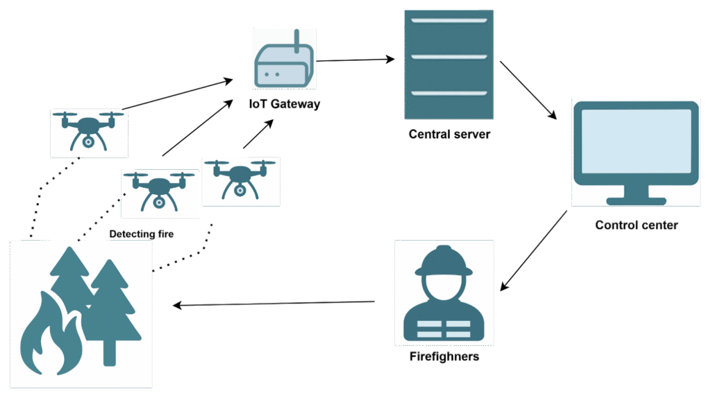
Now let’s analyze it in detail. Let’s start with the drones – in this case, they act as intelligent mobile sensors. They should be equipped with:
- High-resolution cameras (both optical and thermal);
- Gas sensors for smoke detection;
- Temperature sensors;
- GPS modules;
- Built-in modules for local data processing (with possible use of AI).
Their operation would consist of periodic patrols of the forests in shifts (according to battery charging cycles), which would occur autonomously (in which case it would be appropriate to equip the drone with AI), or based on pre-programmed instructions (a cheaper and simpler but less flexible option). During flight, the drone would constantly analyze video and sensor data locally, detecting certain anomalies such as smoke, temperature rise, etc., and upon detection, transmit them to the IoT-Gateway for further processing. Indeed, this already sounds complex, as developing such firmware for the drone, implementing it, and in addition, developing and training AI to improve their autonomy – is no easy task.
Next in the architecture is the IoT-Gateway, which would be responsible for collecting information from the sensors and transmitting it further to the cloud for additional processing. Here there are two implementation options: an onboard gateway located directly on the drone, or a centralized gateway. Let’s look at both options in more detail.
IoT-Gateway onboard the drone (onboard)
Advantages:
- Autonomy – the drone does not depend on ground infrastructure.
- Faster transmission to the cloud (via built-in LTE/5G modem or satellite).
- Less latency: sensors + AI + transmission in a single device.
- Flexibility: can operate even in mountainous/remote regions without terrestrial network coverage.
Disadvantages:
- Limited computing capacity (Jetson Nano/Orin has a performance limit).
- Higher energy requirements (powering the IoT module + modem).
- More expensive drone (all equipment must be onboard).
Centralized IoT-Gateway (on the ground)
Advantages:
- Less load on the drone, resulting in battery savings and longer flight time.
- Easier to maintain, update, and scale gateways.
- Possibility to install industrial gateways with more powerful antennas, processors, and power supplies.
Disadvantages:
- The drone must be within the gateway’s coverage area (LoRa, Wi-Fi, Bluetooth), which is not always possible or optimal.
- Higher communication latency in the system.
- Possible connection failures between the drone and the gateway, which would result in data loss or delayed response time.
A third hybrid option is also possible: drones have onboard gateways (as the primary transmission path). In key areas (for example, near command posts or forest ranger bases), there are centralized ground gateways as a backup or for collecting “heavy” data (videos, maps, reports). This means there are options to choose from that can fulfill the required function, and the choice depends on the specific task and other factors the system will work with.
Thus, when a potential fire is detected (e.g., smoke + heat signature), the drone sends a message via LTE/5G to the nearest gateway, which then transmits it to the cloud. The message may include geolocation, images/videos, sensor readings, etc. It is then passed through an analytics module (using AI is also possible and advisable). The central software module, operating in the cloud or a local data center, receives all messages sent by the drones and determines whether the incident is real and what kind of response is required. The data analysis algorithm can vary, but its main task is to filter out false positives and identify the most likely danger alerts.
After validating the message, the system must respond. There are many ways this can be done. According to the scheme, the message would be forwarded for final confirmation to a specialist’s service, where an appropriate decision would be made, for example, dispatching a fire brigade to the location. However, there could be other options — if the system is very well trained, the operator step could even be skipped, although this might increase the load on fire brigades, so such decisions must be carefully considered. Another option is the development of autonomous firefighting drones, although their development could be as resource intensive as the entire system described above.
Advantages and Disadvantages
Advantages:
- Scalability – easy to add new drones or expand coverage areas.
- Flexibility – the system responds according to the level of threat — not every instance of smoke triggers an alarm.
- Integration – possibility to connect with government services, maps, and climate data.
Disadvantages:
- High implementation cost – the drones alone are expensive, and a considerable number of them is required.
- Dependence on weather conditions – a critical factor that can prevent the system from functioning properly, which can be extremely dangerous without alternatives.
- Dependence on connectivity – another critical factor that can seriously limit the locations where this system can be deployed.
Real-world Applications
Similar systems already exist in some countries, and some are in advanced testing stages.
The California National Guard’s 163rd Attack Wing uses MQ‑9 Reaper drones to collect infrared video during large-scale wildfires. Previously, it took 3–6 hours to create fire maps, but thanks to a new AI process, it now takes only 30 minutes. The drones fly over the fire zone and continuously stream infrared footage to ground stations. This produces crucial fire perimeter maps for CAL FIRE, greatly accelerating the response of firefighting teams.
In March 2025, a system called Silvaguard was presented in Eberswalde (near Berlin). How it works: Silvanet ground gas sensors, installed on trees, detect early smoke signs. This data immediately triggers the launch of a Silvaguard drone. The drone autonomously takes off, captures optical video, and transmits coordinates and images to emergency responders.
In 2024, the NSW Rural Fire Service conducted a two-week test with the Perimeter 8+ drone by Ninox Robotics in Australia. The drone can fly for up to 4 hours and cover a radius of 50 km from the control center. It can operate both day and night, equipped with optical and thermal cameras, streaming live video. It helps emergency services obtain real-time data on initial ignition points (especially lightning-caused fires), greatly improving response planning.
The Pano AI system has been installed on lookout towers in the US and Australia, helping monitor over 2 million hectares of land. This system doesn’t use drones but is more static: 360° panoramic cameras continuously monitor the horizon. An AI filter processes the video, reducing false alarms; the system operates in partnership with human analysts.
Conclusions
Modern natural conditions and climate change are leading to an increase in the frequency and intensity of forest fires worldwide. Traditional response methods are slow, ineffective, and often too late. In response to these challenges, IoT drone technologies equipped with integrated artificial intelligence systems offer a fundamentally new approach — autonomous, mobile, and rapid detection of fires at their earliest stages.
The real-world examples analyzed from the US, Australia, Germany, and other countries demonstrate that the use of unmanned aerial vehicles combined with sensor networks and cloud analytics is already delivering practical results — from reducing the affected areas to improving the accuracy of fire detection.
However, such systems also face a range of technical, logistical, and organizational limitations: limited drone flight times; the need for stable connectivity; false positives from AI; and high costs of procurement and maintenance.
Nevertheless, the potential advantages significantly outweigh the drawbacks, especially when the project is implemented as part of a broader forest monitoring strategy. By combining these systems with ground sensors and satellite surveillance, many dangerous situations can be avoided, and the damage caused by wildfires can be minimized.