
✆ + 1-646-235-9076 ⏱ Mon - Fri: 24h/day
Alternative methods of navigation in GPS denied and cellular denied environments

GPS and cellular connectivity are convenient, but they are not guaranteed. Drones, robots, vehicles, and industrial assets can lose satellite navigation because of indoor operation, tunnels, urban canyons, jamming, spoofing, damaged infrastructure, or deliberate electronic warfare. In those environments, reliable navigation depends on sensor fusion rather than one signal source.
The practical answer is not to replace GPS with one perfect technology. The practical answer is to combine inertial navigation, visual or LiDAR based SLAM, radio ranging, magnetic references, local maps, and onboard autonomy into a layered navigation architecture.
Recent defense and drone coverage shows that this is no longer only a research topic. Media reports about modern UAV products describe combinations of inertial and optical navigation, visual guidance, onboard computing, and alternative communication methods. This article does not focus on any single product. It uses that trend as evidence that GPS denied navigation is already moving into deployed systems. [9]
What GPS denied and cellular denied mean
GPS denied means the system cannot rely on GNSS for position, velocity, or timing. Satellite signals may be blocked, jammed, spoofed, reflected, degraded, or unavailable indoors.
Cellular denial means the system cannot rely on LTE, 5G, NB IoT, or cloud connectivity for map updates, corrections, remote commands, or backend assisted localization.
These two problems are related but different. A system may have GPS but no cellular. It may have cellular but no GPS. In the hardest case, it has neither. That is when local sensing, onboard computing, preloaded maps, and peer to peer communication become critical.
The core idea is layered navigation
A resilient navigation system should not depend on a single source of truth. Each method has a failure mode. The system should validate each signal, estimate current confidence, and decide whether to continue, slow down, stop, return, or wait for recovery.
Figure 1 Layered navigation stack
The stack shows why GPS denied navigation is more than a sensor decision. The validation layer checks whether the current input can be trusted. The fusion layer combines reliable inputs into a position estimate with confidence. The local autonomy layer then makes a safe mission decision even when external connectivity is unavailable.
A useful design rule is simple. INS keeps the estimate alive. External correction sources keep it honest. Local autonomy decides what to do when the estimate becomes less trustworthy.
A quick comparison of navigation methods
| Method | What it provides | Main strength | Main limitation |
| INS and IMU | Relative motion, attitude, heading | Works without external infrastructure | Drift grows over time |
| Visual odometry and visual SLAM | Motion and map from camera images | Low cost and rich scene data | Sensitive to darkness, glare, blur, smoke, and low texture |
| LiDAR SLAM | 3D geometry and localization | Accurate in many GPS denied spaces | Cost, power, weather, dust, glass, and reflective surface limits |
| UWB ranging | Local positioning from anchors or peers | High precision indoors | Requires anchors or nearby nodes |
| LoRa ranging | Long range low power distance estimates | Useful for sparse IoT deployments | Lower precision and update rate than UWB |
| Magnetic navigation | Heading or position from magnetic field patterns | Independent of RF signals | Needs magnetic maps and calibration |
Inertial navigation is the baseline
Inertial navigation systems use accelerometers and gyroscopes to estimate movement relative to a starting point. Advanced Navigation describes INS as an electronic system that uses environmental sensors to measure changes in motion and determine position relative to the starting point. It also notes that accelerometers and gyroscopes are the primary inertial sensors used in such systems. [1]
INS is essential because it provides continuity. It can work underground, indoors, in darkness, during radio silence, and during temporary GNSS outages. The limitation is drift. Small accelerometer and gyro errors accumulate over time. Without correction from GNSS, visual odometry, LiDAR, odometry, barometer, terrain matching, or radio ranging, the estimated position becomes less reliable.
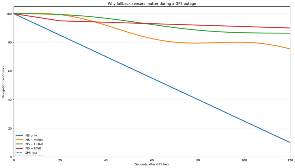
Figure 2 Confidence during a GPS outage
The chart shows a simplified pattern, not a product benchmark. With INS only, confidence decreases as drift grows. Adding vision, LiDAR, or UWB can slow that confidence loss because these methods provide independent correction. The engineering goal is to estimate both position and trust level.
For drones, robots, or mobile assets, INS should output a confidence estimate, not only position. When GNSS disappears, the system should know how long it can safely continue based on IMU grade, vehicle dynamics, mission risk, and available correction sources.
Vision and LiDAR help correct drift
Vision based navigation uses cameras to estimate movement and recognize the environment. It can include optical flow, visual odometry, visual inertial odometry, feature based SLAM, direct SLAM, semantic mapping, and landmark recognition. The business advantage is cost because many platforms already have cameras for perception, inspection, teleoperation, or safety.
The weakness is reliability in difficult visual conditions. Vision can fail in darkness, glare, smoke, fog, snow, fast motion blur, low texture, repeating patterns, and scenes that change often. For UAVs, vibration and motion blur should be treated as core test conditions, not edge cases.
LiDAR measures distance by emitting laser pulses and measuring reflection time. YellowScan explains that LiDAR creates precise spatial measurements and 3D point clouds using reflected laser pulses, and that LiDAR based navigation can work independently of ambient light. [2]
LiDAR SLAM is strong in warehouses, factories, tunnels, mines, urban corridors, industrial yards, and inspection missions where geometry is stable. It can struggle with fog, heavy rain, dust, glass, water, black surfaces, repetitive corridors, and moving crowds. It also adds cost, power consumption, compute load, and integration constraints. [6]
UWB and LoRa provide local radio ranging
Ultra wideband is a strong candidate for local positioning in indoor or campus scale environments. UWB positioning can use time of flight, two way ranging, time difference of arrival, angle of arrival, and phase difference of arrival. FiRa describes UWB as using very short pulses across wide bandwidths and notes that this timing capability enables distance measurements with accuracy in the tens of centimeters. [5]
UWB is useful for factories, warehouses, hospitals, construction sites, ports, and emergency response. It can provide local positioning without GPS and without cellular connectivity, as long as local anchors or nearby cooperative nodes are available.
LoRa ranging has a different role. Semtech documentation and product material describe round trip time of flight ranging support in some LoRa devices. This can support sparse localization, proximity checks, geofence confidence, asset tracking, and emergency fallback where low power and long range matter more than centimeter level precision. [4]
| Method | How it works | Best fit |
| TWR | Tag and anchor exchange packets and estimate distance from round trip time | Small systems and lower infrastructure complexity |
| TDoA | Anchors compare arrival time differences | High capacity tracking with many tags |
| PDoA or AoA | Antenna arrays estimate direction using phase or arrival angle | Direction finding and fewer anchor scenarios |
Figure 3 Method selection matrix
The matrix helps teams compare candidates before deeper architecture work. INS is highly available but drifts. LiDAR and vision can correct drift when the scene contains useful features. UWB can be very accurate indoors but needs infrastructure. LoRa is better for sparse low power tracking than precise robot control. Magnetic navigation can provide an RF independent reference but needs calibration and reference data.
Magnetic and signal direction methods add references
Magnetic navigation uses Earth magnetic field patterns and magnetic maps as a reference. PNI Sensor describes MagNav as a GPS alternative that compares measured magnetic field data against magnetic reference maps and is independent of RF jamming and spoofing. [3]
The attraction is clear. Magnetic navigation does not depend on satellites, cellular towers, or active radio signals. The limitation is deployment complexity. It depends on magnetic map quality, sensor calibration, vehicle magnetic interference, environmental anomalies, and filtering.
Angle of arrival methods estimate the direction from which a signal arrives. They can help localize cooperative nodes, beacons, emergency transmitters, local gateways, or RF landmarks. The tradeoff is hardware and signal processing complexity. Antenna placement, calibration, multipath, and line of sight conditions matter.
Cellular denied operation is an edge autonomy problem
When cellular connectivity is denied, navigation design becomes an edge computing problem. The system cannot assume cloud map access, cloud inference, network corrections, remote operators, or real time backend commands. It must continue locally.
- Preloaded maps or local map building
- Local route planning and obstacle avoidance
- Local confidence estimation
- Store and forward logs
- Fallback behavior when localization uncertainty grows
- Peer to peer communication when useful
- A recovery policy for reconnecting later
For IoT products, this has product implications. A backend dashboard should show not only the last known location, but also the confidence source. GPS fix two minutes ago is different from dead reckoning estimate for two minutes after GPS loss.
What should a resilient navigation architecture include
| Layer | Purpose | Typical components |
| Sensing | Collect raw information | IMU, camera, LiDAR, UWB, LoRa, magnetometer, barometer, odometer |
| Validation | Decide which inputs can be trusted | Spoofing checks, blur detection, scan quality, magnetic disturbance, anchor health |
| Fusion | Estimate state and uncertainty | EKF, factor graph, particle filter, VIO, LiDAR inertial odometry |
| Local autonomy | Select safe behavior | Continue, slow, stop, return, safe mode, operator request |
| Synchronization | Recover backend state later | Logs, map updates, diagnostics, incident history |
Fordewind relevance
Fordewind has relevant experience in IoT embedded systems, mobile applications, cloud platforms, BLE communication, vehicle data, and asset tracking. The Connected Car Platform case study describes an OBD II device, BLE communication, mobile app integration, real time monitoring, trip reports, car finder, crash response, and vehicle health features. [7]
The Smart Asset Tracking System case study describes BLE tags, RFID, GPS, mobile apps, and real time asset visibility for logistics and supply chain operations. [8]
This experience maps naturally to navigation resilience work. A GPS denied system is not only a navigation algorithm. It also needs embedded firmware, sensor integration, mobile and cloud workflows, diagnostics, OTA updates, field testing, and clear user interfaces for location confidence.
- Navigation fallback architecture for IoT devices
- Embedded sensor fusion prototypes
- BLE, UWB, LoRa, GNSS, and IMU integration
- Fleet dashboards with location confidence
- Offline first mobile apps for field devices
- Cloud pipelines for navigation logs and diagnostics
- Test automation for GPS loss, cellular loss, and sensor degradation scenarios
Practical checklist for product teams
- What environment will the product actually operate in
- How long must it survive without GPS
- How long must it survive without cellular
- What accuracy is required during outage
- Is the position used for safety, billing, analytics, or convenience
- Can the environment support anchors, beacons, or local gateways
- Can the device carry LiDAR, or only camera and IMU
- What is the power budget
- What is the acceptable failure behavior
- Will users see confidence level, or only a location point
- How will the system be tested against jamming, spoofing, blur, dust, darkness, and network loss
FAQ
Can GPS denied navigation be solved with only an IMU
Only for short periods. IMUs provide continuity, but their error accumulates over time. For reliable operation, INS should be corrected by another source such as vision, LiDAR, odometry, UWB, magnetic references, terrain matching, or GNSS when it becomes available again.
Is LiDAR better than camera based SLAM
Not always. LiDAR works well in low light and provides accurate geometry. Cameras are cheaper and provide rich visual information. The best choice depends on lighting, weather, cost, compute, power, and safety requirements.
Can UWB replace GPS
UWB can replace GPS only in local environments where anchors are installed. It is excellent for indoor positioning, factories, warehouses, hospitals, and campuses, but it is not a global navigation system.
Is LoRa ranging accurate enough for navigation
Usually not for precise robot navigation. It is more useful for long range, low power, zone level localization, proximity, and asset tracking.
Is magnetic navigation immune to jamming
Magnetic navigation does not rely on radio signals, so RF jamming and spoofing do not attack it directly. It still depends on magnetic map quality, sensor calibration, and protection from local magnetic interference.
What is the best architecture for GPS and cellular denied operation
The best architecture is layered. Use INS for continuity, vision or LiDAR for drift correction, local radio ranging when infrastructure exists, magnetic or map based references when suitable, and local autonomy for safe behavior during uncertainty.
Conclusion
GPS and cellular connectivity are useful, but resilient systems should not be built around their constant availability. The future of navigation is layered, local, and confidence aware.
For developers, this means sensor fusion, validation, offline behavior, and edge autonomy. For business decision makers, it means fewer failed missions, safer devices, better field reliability, and clearer diagnostics when the environment becomes hostile or simply disconnected.
If your product depends on location, start by testing what happens when GPS and cellular connectivity disappear at the same time. The result will quickly show whether your system has navigation resilience or only a map icon.