✆ + 1-646-235-9076 ⏱ Mon - Fri: 24h/day
Drone Technology and IoT: The Perfect Pair for Smart Farming
Imagine a morning field where, instead of dozens of workers, a drone quietly and smoothly flies by. It carefully scans the soil, examines the condition of the crops, and collects data on temperature, humidity, and nitrogen levels — all within just a few minutes. The scene feels like something straight out of Christopher Nolan’s Interstellar. In the film, there was a chase for a drone, with the idea of turning it into a smart farmer. Just over ten years have passed since the movie’s release, and what once seemed like science fiction is quickly becoming today’s reality in the ever-evolving agricultural world.
Agriculture now faces serious challenges. Every year it becomes harder to find seasonal labor for fieldwork. Climate change brings unstable harvests, droughts, and migrating pests. This leads to inefficient use of resources — water, fertilizers, fuel — resulting in significant financial, and often environmental, losses. In such circumstances, there is a clear need for technologies that can make farming precise, predictable, and manageable.
As always, in situations like this, technological progress comes to the rescue. Here, the game changers are drone technologies and the Internet of Things (IoT). Together, they form a powerful duo capable of redefining how food is grown. Not enough workers to inspect or treat the field? Drones can provide fast and detailed aerial monitoring and even perform certain actions for crop care both from the air and on the ground. How to keep everything under control? Sensors continuously monitor the field, transmitting data in real time to an IoT system. From there, a reliable digital “brain” processes the information, analyzes it, and delivers ready-made insights, reports, and alerts to the farmer.
Today, agriculture has the opportunity to optimize itself dramatically with the help of these technologies. The combination of drones, IoT, and modern software gives farmers a powerful new tool — smart farming. It doesn’t just make their work easier, but opens entirely new horizons for productivity, quality, and sustainable growth.
What is Smart Farming?
Smart Farming is a modern approach to agriculture that relies on digital technologies to increase efficiency and productivity. It goes far beyond simple automation — it is a deep transformation of how crops are grown and livestock are cared for. Every decision is made based on accurate, real-time data.
At the core of Smart Farming lies the Internet of Things (IoT) — a network of devices, sensors, and systems capable of communicating with each other, collecting, and transmitting information without human intervention. This ecosystem includes:
- Soil sensors that measure moisture, pH, and temperature levels;
- Weather stations for localized weather forecasting;
- GPS trackers for precise positioning of machinery;
- Smart irrigation systems that activate only when needed.
But IoT is just one piece of the puzzle. Big Data enables the storage of massive amounts of collected information and helps identify patterns — when it’s best to sow, when to expect pests, or when to apply fertilizers. Machine Learning takes this a step further by making predictions accurate and tailored. Algorithms trained on real agricultural data can not only analyze the current situation but also forecast risks or suggest ways to increase yield in a specific field.
Key advantages of Smart Farming:
- Cost optimization (farmers use less water, fertilizers, and fuel — only where and when it’s truly needed);
- Precision agriculture (treating land on a square-meter level rather than entire fields at once);
- Real-time monitoring;
- Yield forecasting;
- Environmental sustainability (efficient resource use reduces negative ecological impact).
As a result, Smart Farming is not just a useful addition but a necessity for the modern farmer who wants to stay competitive, reduce dependence on weather-related risks, and fully unlock the potential of their land.
The Role of Drones in Agriculture
The system described above can already be used effectively. However, when drones are added, it’s like the cherry on top. Drones can serve as the eyes, ears, and even the “hands” of modern farmers. They can become an integral part of the smart farming infrastructure, as they are capable of quickly covering large areas, performing complex tasks, and providing information that was previously either inaccessible or required significant time and effort to gather.
In agriculture, two main types of drones are commonly used:
- Multicopters (quadcopters, octocopters, etc.) — the most widespread type of drone, equipped with multiple rotors and capable of hovering in one spot. Their key advantage is high maneuverability and precision. They are ideal for detailed monitoring of smaller fields, targeted spraying, or inspecting problematic areas.
- Fixed-wing drones — better suited for large-scale operations. They have longer flight ranges and can cover dozens of hectares in a single flight. They are used for general monitoring, mapping, and large-scale aerial photography.
Main tasks performed by drones:
- Aerial imaging of fields — using standard or specialized cameras, drones produce highly accurate images. These are used to create orthophotos, detect irregular crop growth, and monitor changes in soil or vegetation.
- Thermal diagnostics of crops — with thermal cameras, drones can identify areas of water stress, overheating, or early signs of disease, which is crucial for timely intervention and reducing yield loss.
- Spraying fertilizers, pesticides, or water — equipped with liquid tanks and precision spraying systems, drones enable efficient resource use and minimize environmental impact.
- Soil and moisture monitoring — with advanced sensors capable of detecting soil moisture via spectral analysis or temperature changes, drones help make irrigation decisions based on data rather than intuition.
Sensors installed on drones include:
- RGB cameras — standard visible-spectrum cameras for plant condition assessment and orthophoto mapping.
- Multispectral cameras — capture light in multiple spectral ranges (e.g., red, green, near-infrared) to analyze vegetation health.
- NDVI sensors (Normalized Difference Vegetation Index) — evaluate plant health by measuring photosynthetic activity.
- LIDAR (Light Detection and Ranging) — laser scanning technology that creates precise 3D terrain maps, useful for studying soil erosion or elevation differences.
How IoT Complements Drone Solutions
Despite the impressive capabilities of drones, it’s clear that they alone cannot provide a complete picture of field conditions. That’s where the Internet of Things (IoT) comes in, turning fields into a “living organism” and forming the backbone of smart farming.
IoT sensors placed directly in the field provide continuous monitoring of key parameters, such as:
- Soil moisture levels;
- Air and ground temperature;
- Soil acidity (pH);
- Light intensity;
- Fertilizer or salt concentration.
These sensors transmit data to a central system via wireless communication protocols.
The collected data can:
- Be stored locally (at the gateway);
- Be sent to cloud servers for deeper analysis;
- Be accessed by the farmer via a mobile app or web-based analytics dashboard.
Device Interaction: IoT + Drones + Servers
The true power of IoT lies in creating an integrated ecosystem. For example:
- Sensors detect a drop in soil moisture in a certain area;
- The system instructs a drone to perform a follow-up flight for visual confirmation or targeted spraying;
- The server processes all incoming data and generates recommendations for the agronomist (or even automatically activates the irrigation system).
This real-time interaction not only provides visibility but also enables immediate responses, reducing risks and losses.
Cloud or Hybrid Infrastructure
For storing and processing data, the most common options are:
- Cloud solutions (e.g., AWS IoT, Google Cloud IoT, Azure IoT) — offer scalability, high availability, and integration with AI tools for advanced analytics.
- Hybrid architectures — part of the processing happens locally (on gateways or edge devices), while the rest is handled in the cloud. This is useful in areas with limited internet coverage or when ultra-fast responses are required.
Popular communication technologies between sensors and servers include:
- LoRaWAN (Long Range Wide Area Network): ideal for transmitting small data packets over long distances. Energy-efficient, allowing sensors to run for years on a single battery.
- NB-IoT (Narrowband IoT): leverages mobile networks for data transmission, with reliable coverage even in hard-to-reach locations. Works well for farms with 4G/5G coverage.
- ZigBee: a local network for short-range data exchange, often used in greenhouses or compact farms.
These technologies allow farmers to build flexible, scalable monitoring systems that deliver analytics in real time. In this ecosystem, drones are no longer standalone devices — they become part of an intelligent IoT swarm, where every element complements the others.
System Architecture
When viewed as a whole, the system can be described as: field sensors and drones → IoT gateway → server → frontend interface (web or mobile). Schematically, it looks like this:
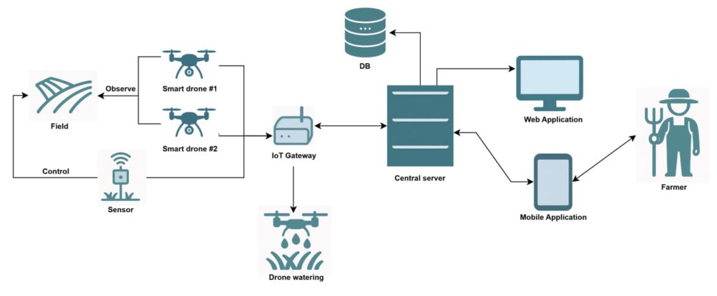
IoT-gateway — is the intermediary between low-level IoT devices (sensors, drones) and the backend (cloud or on-premise server). Its functions include:
- Receiving data from devices that use low-power protocols (LoRaWAN, ZigBee, Bluetooth, serial ports);
- Converting data into server-compatible formats (e.g., JSON, Protobuf);
- Sending data to the backend via standard internet protocols (MQTT, HTTP, WebSocket, gRPC).
At the core of the system is the backend, which acts as the computational engine. Its functions:
- Receives data from the IoT gateway via MQTT, REST, or WebSocket;
- Stores information in databases (e.g., PostgreSQL or MongoDB);
- Processes data using ML models (e.g., detecting risks, predicting yield, generating recommendations);
- Exposes REST APIs for interaction with the frontend (analytics dashboards or mobile apps).
The farmer-facing mobile or web application can include:
- Interactive field maps with zones, sensor data, and drone data overlays (moisture, temperature, NDVI, etc.);
- Charts and analytics for each parameter (moisture, pH, temperature, vegetation health, yield forecasts);
- Report generation in PDF/Excel with historical field data;
- Real-time alerts about critical parameters, system failures, drone/sensor task completion;
- Drone control (from mobile): launching flights, selecting spraying areas, checking drone status;
- Irrigation control: manual switching or automated modes based on soil moisture;
- GPS integration for precise equipment positioning and event logging.
Real-World Use Cases
1. AgEagle: platform, in particular such a model as eBee Ag, is equipped with both an RGB and a multispectral camera (for example, Duet M), which allows capturing NDVI, NDRE, and DSM with a resolution of up to ~2.5 cm (with RTK) during a single flight lasting up to 55 minutes, covering up to 1.6 km² of land. In cooperation with Kansas State University, a drone with a RedEdge camera performed wheat monitoring within 1 ha in 10 minutes, and the collected NDVI data showed a high correlation (R² ≈ 0.82–0.87) with yield and soil samples, which allowed for effective calibration of nitrogen variable-rate application algorithms. Thus, the AgEagle system makes it possible — based on accurate imagery — to create “prescription maps” for targeted fertilizer application, saving resources and increasing yields.
2. Gamaya: offers solutions based on hyperspectral cameras that capture up to 40 spectral bands. The processing system includes orthomosaic stitching from drone images and the application of ML algorithms to detect crop stress, weeds, nutrient deficiencies, or diseases before they become visible to the human eye. Originally, until 2020, Gamaya processed entire fields, but with the increase in field sizes (up to hundreds of hectares) the strategy changed to dividing polygons into fixed grids; now, processing a large field of up to ~500 ha takes less than 30 minutes on small cloud-based machines — reducing costs by 10 times and significantly increasing the speed of new model development.
3. Aerobotics: One of the key platforms — Aeroview, which combines drone data, satellite imagery, and field observations. The platform analyzes tree health, pest presence, vegetation levels, irrigation status, fruit count, and canopy volume using ML models trained on a large dataset (>81 million trees and >1 million fruits).
Implementation in Real Conditions
Although drone and IoT technologies may seem complex, their adaptation for small or medium-sized farms is entirely feasible. The key is to approach implementation step by step and consciously, based on the real needs of the farm.
How to adapt such a system:
- Start with the problem you want to solve: for example, inefficient irrigation, difficulty monitoring large areas, or the need for yield forecasting.
- Launch a pilot project on a single plot (5–10 ha). Choose a simple configuration:
- drone with a specialized camera for weekly flights;
- several moisture/temperature sensors at different points in the field;
- an IoT gateway for data collection;
- backend with basic visualization (a simple web interface or app).
- Automate reports and alerts to get feedback without extra effort (e.g., push notifications when soil moisture drops).
- Gradually integrate the system: add new plots, sensors, irrigation control, and data processing with ML models.
Such a system will help at relatively low cost to understand how effective and necessary this implementation is for the farm.
Possible challenges
- Internet coverage
- In rural areas LTE/4G may be unstable. Solution: use LoRaWAN for low-power sensors, and for the gateway — an external LTE antenna or Starlink.
- Data accuracy
- Incorrect sensor placement → false results;
- Calibration checks and real-time fault detection are required.
- Security
- IoT devices often have vulnerabilities (open ports, weak passwords). Important: use TLS connections, update firmware, and restrict external access.
- Drone certification
- In some countries, drones above certain weights require registration, and pesticide spraying needs additional permits.
- Legal requirements should be considered, and operators certified (especially for spraying).
Conclusion
Smart farming, which combines drones and IoT, opens new opportunities for agricultural businesses of any scale. It helps significantly increase monitoring accuracy, reduce resource costs, improve yields, and make processes more predictable and controllable.
Drones provide fast and detailed field inspections, thermal and multispectral plant diagnostics, while IoT sensors collect crucial real-time data on soil and environmental conditions. A server with modern data processing and analytics technologies transforms these massive streams of information into practical recommendations for the farmer.
The implementation of such systems, even in small and medium-sized farms, is already relatively affordable today. At the same time, technical and regulatory challenges must be considered: internet coverage, security, data accuracy, and drone legality.
In the end, smart farming is not just technology, but a new method of farming that enables efficient resource use and makes agricultural business more sustainable under modern climate and economic conditions.